Your data. Your outcomes - biodiversity information handling and data quality
Posted by AaronClausen
18 Oct 2023
Hi everyone,
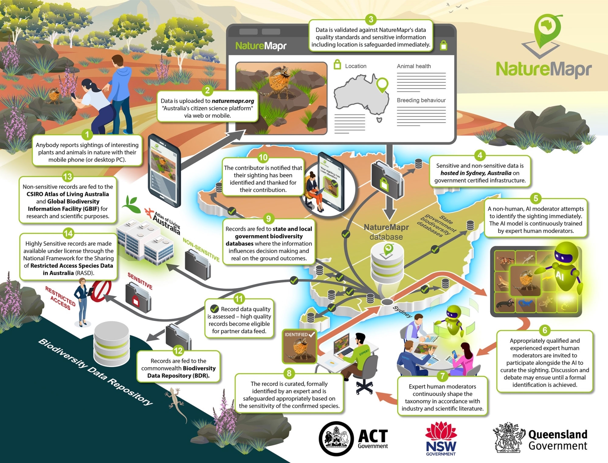
The team have been working extremely hard on putting together NatureMapr's transparent biodiversity information handling and data quality standards.
NatureMapr's mission is to empower anybody to report plant or animal information anywhere in Australia and ensure the information gets to the people that need to know about it.
Part of that mission is to ensure Aussie biodiversity information is easily and readily accessible so it can be used to help achieve real world outcomes for the environment.
Australia's biodiversity data is a unique and special asset which deserves to be handled accordingly.
NatureMapr is responsibile for handling and safeguarding this information appropriately - and it's a responsibility we've always taken extremely seriously.
Our promise is that we will always be completely transparent to you about where your data goes and what we do with it.
Thanks to you - our incredible community of contributors and expert moderators, you are helping ensure high quality biodiversity information makes its way through to multiple levels of Australian government decision makers.
We hope to be able to elaborate more on an exciting new partnership in this space before the end of the year.
11 comments
Jenny Edwards
Nature Coast Marine Group
That's great - anything and everything that inspires and motivates people to look after the environment is an extremely positive thing.
Platform choice is a good thing - just like you can use a Windows PC or an Apple Mac. Ultimately the end user benefits from that choice.
Both platforms take their own approach to supporting citizen science (= win win for the environment).
It is very important for NatureMapr to be fully transparent with our users regarding what happens with their data, where it is hosted, how it is safeguarded and what happens to it downstream and we encourage all of our users to read up on that and to make their own informed choice: https://naturemapr.org/content/naturemapr-biodiversity-information-handling
We are Australian made, Australian owned and focused entirely on establishing direct relationships and data exchange with multiple Australian government databases at multiple levels to ensure the data gets through to where it can influence real world decision making.
All sighting records on NatureMapr are curated and formally identified by an expert who:
- Is formally qualified; OR
- Has relevant professional experience; OR
- Has a demonstrated track record in identifying species within their category(ies) of expertise;
AND
- Is entrusted by at least one other moderator and/or administrator
Getting more clarity around data handling on CNM is really important for users and I'm very pleased to see this being addressed thoughtfully and aligned with ala principles.
I've been recently been surprised to find the locations of some plant species in the "Very rare/Threatened" conservation level being able to be seen by all users.
It now seems you have a new category to define which species locations are seen and which are not called "Highly sensitive sighting", but I can't find anywhere on the CNM site what the definition of that category is and how it relates to the conservation levels.
Could you please point me to where I can find that information.
Thanks,
Warren
(aka sangio7)
Thanks for the feedback on this. The safeguarding (suppression of precise location) of records is driven by the Sensitivity Level as opposed to the Conservation Level.
"Very rare/threatened" is a conservation level value, which is independent to the record's Sensitivity Level.
Sensitivity Level of a species can only have 3 possible values. Not Sensitive, Sensitive or Highly Sensitive.
These values are maintained by the expert moderator community and do change from time to time based on their latest understanding of a particular species.
That said, if at any time you feel a particular species should be treated as Highly Sensitive but is not, we definitely encourage you to reach out to a relevant moderator and/or submit a contact us form to raise and discuss the matter further. The whole taxonomy is a living breathing thing and is continually being maintained and improved as per: https://naturemapr.org/species/updates
Are you able to share the considerations that go into making the decision to classify as "Highly sensitive"?
NatureMapr enlists appropriately qualified or experienced expert moderators who we trust to maintain appropriate levels for species in consultation with formal advice from government.
That does not eliminate all possibility of a particular species attracting a new sensitivity level over time nor does it eliminate all possibility of human error and/or the community missing something. However, if that legitimately does occur, the mechanisms are in place to bring any examples to the attention of moderators for their consideration.
If you can provide me with any specific examples, we will definitely pass to the appropriate moderators to consider. There is a section on our Contact Us form specifically for taxonomy related changes and/or enquiries and this is exactly what it is used for.
Cheers
Aaron.
Obviously a user recording a sighting can check the location display status of that species and decide for themselves whether to proceed. And I assume that locations that users asked to be suppressed are respected and override any sensitivity classification?
Thanks,
Warren
A contributor can choose to manually suppress the location of any sighting due to private property or privacy reasons, which overrides and takes precedence. The effect is that the sighting is treated exactly the same as if it was a Highly Sensitive species.
Please check our social media for details.